UK - Scotland Map Reference
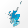 |
Map: UK - Scotland |
|---|---|
| File Path: europe\uk_scotland.amap | |
| Bounds: (-8.61861228942871,60.8444404602051,-0.73888897895813,54.6272201538086) | |
| Default Projection: orthographic |
Map Built-In Data Table
| REGION_ID (K) | REGION_NAME (K) | CENTROID_X | CENTROID_Y |
|---|---|---|---|
| GBR-SCT-BRD | Borders | -2.77819454669952 | 55.530345916748 |
| GBR-SCT-CNT | Central | -4.17338299751282 | 56.2180500030518 |
| GBR-SCT-DAG | Dumfries and Gal | -4.01812505722046 | 55.0448551177979 |
| GBR-SCT-FYF | Fyfe | -3.16012358665466 | 56.2312488555908 |
| GBR-SCT-GRM | Grampian | -2.77944457530975 | 57.2326354980469 |
| GBR-SCT-HGH | Highland | -4.8991664648056 | 57.5933284759521 |
| GBR-SCT-LTH | Lothian | -3.09161591529846 | 55.8866653442383 |
| GBR-SCT-ORK | Orkney | -2.89875054359436 | 59.0629138946533 |
| GBR-SCT-SHT | Shetland Islands | -1.41847252845764 | 60.1762447357178 |
| GBR-SCT-STT | Strathclyde | -5.19263911247253 | 55.8406887054443 |
| GBR-SCT-TYS | Tayside | -3.57138895988464 | 56.5564842224121 |
| GBR-SCT-WIS | Western Isles | -7.38416719436646 | 57.646800994873 |
![]()