South Atlantic Map Reference
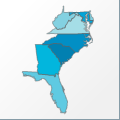 |
Map: South Atlantic |
|---|---|
| File Path: usa\sub_regions\states\south_atlantic.amap | |
| Bounds: (-87.6257247924805,40.6371383666992,-75.0459976196289,24.9559669494629) | |
| Default Projection: orthographic |
Map Built-In Data Table
| REGION_ID (K) | REGION_NAME (K) | STATE_FIPS (K) | SUB_REGION | CENTROID_X | CENTROID_Y |
|---|---|---|---|---|---|
| DC | District of Columbia | 11 | S Atl | -77.016918182373 | 38.890775680542 |
| DE | Delaware | 10 | S Atl | -75.4187164306641 | 39.1447486877441 |
| FL | Florida | 12 | S Atl | -83.838436126709 | 27.979471206665 |
| GA | Georgia | 13 | S Atl | -83.2519569396973 | 32.6806678771973 |
| MD | Maryland | 24 | S Atl | -77.2680435180664 | 38.847749710083 |
| NC | North Carolina | 37 | S Atl | -79.8904151916504 | 35.2358207702637 |
| SC | South Carolina | 45 | S Atl | -80.965259552002 | 33.6381015777588 |
| VA | Virginia | 51 | S Atl | -79.4589233398438 | 37.9991912841797 |
| WV | West Virginia | 54 | S Atl | -80.1875152587891 | 38.9209671020508 |
![]()