Northeast Map Reference
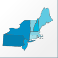 |
Map: Northeast |
|---|---|
| File Path: usa\regions\states\northeast.amap | |
| Bounds: (-80.526252746582,47.453296661377,-66.9698486328125,38.9565696716309) | |
| Default Projection: orthographic |
Map Built-In Data Table
| REGION_ID (K) | REGION_NAME (K) | STATE_FIPS (K) | SUB_REGION | CENTROID_X | CENTROID_Y |
|---|---|---|---|---|---|
| CT | Connecticut | 09 | N Eng | -72.7571983337402 | 41.5228157043457 |
| MA | Massachusetts | 25 | N Eng | -71.708797454834 | 42.0624713897705 |
| ME | Maine | 23 | N Eng | -69.0289192199707 | 45.2721290588379 |
| NH | New Hampshire | 33 | N Eng | -71.6442680358887 | 43.9999675750732 |
| NJ | New Jersey | 34 | Mid Atl | -74.7335777282715 | 40.1535243988037 |
| NY | New York | 36 | Mid Atl | -75.8169708251953 | 42.7559986114502 |
| PA | Pennsylvania | 42 | Mid Atl | -77.613353729248 | 40.9932518005371 |
| RI | Rhode Island | 44 | N Eng | -71.4924049377441 | 41.6681423187256 |
| VT | Vermont | 50 | N Eng | -72.4711380004883 | 43.8695373535156 |
![]()